It’s all about location, location, location. Thinking in space here, as you choose a seat at a restaurant dinner table.
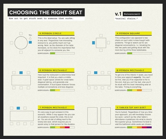
via Nag on the Lake

It’s all about location, location, location. Thinking in space here, as you choose a seat at a restaurant dinner table.
via Nag on the Lake
Posted in humor, spatial thinking
So very honored that my colleague Patrick Meier included me in this list of women who work on crisis mapping efforts around the world. Thank you, Patrick! It’s true, there are many of us and we love what we do. My volunteer efforts with the Standby Task Force are more gratifying than much of my regular work. We’re preparing now to contribute the behind-the-scenes maps for Harvard’s upcoming Humanitarian Studies Initiative simulation weekend in April. I’d like to be on the ground for it sometime, but will instead be organizing volunteers to generate situation reports every few hours.
Posted in crisis mapping
Next week I’ll be visiting Marymount College, speaking about the roles of spatial thinking and geography for reasoning and communication. I will also have the opportunity to visit a number of classes and share ideas with students directly. I look forward to understanding what they know and want to know. My class visits will range from courses on Aging in America, to Digital 3D Modeling, to Applied Intercultural Psychology. What, they think spatial thinking is relevant to all of these? They’re right!
Posted in higher education, spatial thinking
This year we’re supporting several faculty projects that involve mapping “knowledge” – collections of ideas, groups of people, collections of objects. They have both geographic and non-geographic attributes. Eventually the faculty, and their students, will use spatial thinking to extract meaning from the representations: what are the relationships among the components, based on distance, connections, sequences.
To begin, we’re playing with NodeXL, but are likely to branch out to more customized tools later.
I like Flash-based interfaces, like this one that lets you explore the Abstraction movement of art history, from MoMA. Sites like these have matured. Instead of just including the graphical network itself, it’s now a multi-media experience, with other text, images, audio, etc., to expand and illustrate. I really like these.
Posted in data & visualization, spatial thinking
Basically, here’s where I think some of the tensions emerged during and after the December 2012 Spatial Thinking Across the College Curriculum gathering.
Tension #1: Thinking about spatial thinking – within higher education – is actually a livelihood for some people. It’s not a curiosity or a hypothetical situation, it’s actually a mainstay. A central tendency. A constant. The whole enchilada. The full monty. Whatever your metaphor, folks (like me) who spend 8-10 hrs/day at this aren’t always the most effective ones to slowly and patiently consider the options. We want to move forward ambitiously with plans, especially when we work at an institution that drinks the koolaid.
While, for a bulk of the people at most institutions, these ideas really are just a curiosity and a hypothetical. The ideas take place in a vacuum, whilst away at a lovely conference, and they won’t likely be grappling with the thorns of actual implementation.
Tension #2: Reaching consensus about exactly *what* we’re talking about always seems insurmountable, so we agree that proceeding in the absence of common definitions isn’t a problem, but in the end, it always is. The psychologists need measurable assessment of definable tasks in replicable situations in manageable spaces with willing volunteers. The geographers delight in the fact that their knowledge and skills can be grouped under the umbrella of spatial thinking, but their practices don’t align with the unfamiliar tasks being researched by the psychologists. The typical usage of GIS in educational settings supports some practices of spatial thinking, when we define it to include reasoning about and through patterns, distances, scales, associations, spatial dependencies, etc., but – in reality – infrequently overlaps with the primary areas that spatial cognition psychologists actually study (mental rotation, disembedding, spatial perception, etc.).
Basically, we still haven’t reconciled that these spatial relations, as called by Reg Golledge, are still the most interesting practices for geographers, and the least likely ones to become measurable tasks that are studied by psychologists.
Do I think that there’s a possibility for spatial thinking to play a significant role across a college campus? You bet I do. But we can’t be intimidated by the task of creating working definitions, and applying them. Spatial thinking includes the mental rotation that is happening in physics and studio art classes. It includes the drafting of sheet music and seating charts that is happening in music classrooms and catering offices. When applied in geographic space, it can become the competent and confident knowledge of why there is plastic garbage accruing in the North Pacific Ocean and why Atlanta annually gets more rain than Seattle and why Jerusalem is such a complicated city.
So I think this is the crux of the matter: we can’t agree on the scale and extent of the knowledge, skills, and practices of “spatial thinking” and, therefore, how one would pursue its agenda in higher ed. Geospatial is distinctive from spatial, and while most or all of geography involves spatial thinking, no card carrying engineer or architect would identify the spatial nature of their practices being aligned with the practices of a geographer. Really, people, distance is distance.
Stay tuned for the published official report on the conference.
Posted in conferences, higher education, spatial thinking
I think this is cool, the Virtual Paintout. Each month, the owner of this site (Bill Guffey) chooses a new location (city, island, region, country) and announces the venue. For January 2013, it’s the Isle of Man. For the rest of the month, anyone in the world is encouraged to explore that site via Street View and create a painting based on that perspective. Digital versions of the paintings are published throughout the month, as they’re received, and when the contributors can follow the rules.
It becomes a way for artists to promote their work, but it’s also inspiration to explore the imagery further. Viewing via Street View, versus an overhead, planar perspective, creates a greater sense of place. We need to see more than rooftops alone.
Posted in art and design, humanities, imagery
During that first day of our Spatial Thinking conference, we had some discussions about *what* spatial content should (could? would?) be covered in these efforts. As we considered that need, Lynn Liben reminded us to be systematic in our decision-making, to have goals that were generative and aimed at the meta-cognitive level. Her meta-cognitive criterion resonated strongly with me. This is about habits of mind, and we feel the implications for this way of thinking go far beyond any individual task. Given the need to work collaboratively and effectively through partnerships, she envisioned a possible new profession of “spatial curriculum specialist,” someone who would work work with educators to “identify and respond to learner needs for specific content.” [Editor’s note: how well does a typical GIS Specialist fill this role? How many have a broad enough perspective to couch their instructional expertise within a spatial thinking framework? What would help them be more confident and competent in that area?]
Mike Goodchild began with some of his regular stories: 1) the unnecessary complexity of ArcToolbox, a collection that is poorly and unevenly constructed and organized, and in no way intuitive for someone using a spatial thinking “filter” to anticipate or find the tools (contributing to perpetual user frustration); and 2) the unsuitability of US counties as areas for unit analysis, based largely on their variability in size and inconsistent geographies over time.
But Mike’s most powerful message was his singling out spatial dependence and spatial heterogeneity as the two linchpins for the power of space, setting up an intellectual imperative for why spatial thinking must not be ignored or trivialized. He set up the argument by drawing comparisons with science and statistics. Science is only possible when generalizations can (eventually) be made, and (parametric) statistics is only possible when one can assume data independence. If one fails to understand those two ideas, then any resulting scientific and statistical analyses will necessarily be flawed.
However, heterogeneity and dependence, two significant truths of our spatial world, are in conflict with generalization and independence, by definition. Thus, if one fails to understand and account for those two ideas, then any resulting spatial analyses will necessarily be flawed.
An underlying, ulterior motive for this Conference was to evaluate whether a compelling and competitive proposal can be made to the National Science Foundation to support spatial thinking educational efforts, and Mike was building up the research rationale.
Kim Kastens, my geoscience/spatial hero, encouraged us to consider two fronts of attack: specialization and alliances. By specialization, she suggested that spatial thinking is too broad and ambiguous for *all* schools to consider it interesting. Build up a few with very strong reputations, have them able to “pull” students to this area of specialized content, and see what happens after that. We wondered whether Southern California might become this kind of Mecca, with Redlands, UCSB, and USC all within a sunny day’s drive of one another, and all with initiatives in this area.
Kim also urged the group to consider a spatial thinking / critical thinking alliance. Specifically, the critical thinking audience has invested heavily in generating a “valid” assessment instrument, and we should follow their lead in this area.
And, Kim was the first to talk out-loud at this meeting about a MOOC on spatial thinking. What a concept!
David DiBiase introduced the notion of “micro-insertions” as a strategy for promoting spatial thinking. As examples of how to act small but think big, he highlighted examples of the numerous places where maps, or geographically-enhanced charts, or spatial analyses, would be natural fits into two of the most widely used psychology and economics textbooks in the United States, reaching tens of thousands of students each semester. Easy, straight-forward, non-confrontational ideas in theory, with a potentially very large audience, though uncertain that implementation would have the easy button on its side.
My thoughts on Dave’s ideas are from the assessment perspective. All of Dave’s ideas are “geography” as connections. Yes, we can make all of these changes. To convince the authors and publishers, we have to say why. How can we tell if it would make any difference to the learning of economics? If students and faculty saw these maps, instead of graphs and tables, how would it affect the learning? Affective – because people would enjoy looking at the maps longer? Would they learn the content differently?
Though it would have made the meeting even more contentious than it was, we could have benefited from a few true skeptics in the room. Or not just skeptics, but clueless newcomers. We weren’t just preaching to the choir, but we’ve been all members of the choir for so long that we don’t even know how to tell people why we’re singing any longer. It’s just the sound that comes out when we open our mouths. Spatial thinking “makes a difference;” making new content “greatly deepens” our understanding. Really? Why? How? Show me, don’t just tell me.
Intellectual imperatives can’t be faith-based alone, or rely on anecdotes exclusively, as much as we all love a good story.
Next: final thoughts on the STACC conference.
Posted in conferences, higher education, spatial thinking
Earlier this week I was part of a 2-day conference on Spatial Thinking across the College Curriculum, in Santa Barbara. There were about 46 of us, a broad mix of largely comprised of geographers and psychologists, with a few scattered from other disciplines (landscape architecture, anthropology, physics, chemistry, computer science, history).
In organizing this event, we’d laid out a series of questions that we thought we might be able to tackle.
But, in the end, our conversation was a bit too far ranging to discuss many of these with specificity.
For most people the meeting’s topic could only be imagined in the hypothetical. Their own institutions have little or no interest in these topics, and their own interests, be they spatial cognition or geography education, are just that – their own interests.
Others of us live and breathe this topic every day. We’ve thought through many of these questions before, and may even already have prototypical implementations of curricula in place. So it was difficult to launch into new areas of conversation without having to catch others up, to back fill, or to explain first. And it wasn’t just explaining methods or techniques. At times we were starting at square one, seeming to question the validity of the premise itself – that spatial learning and thinking is significant enough that it merits a much more substantial place within our formal educational environments.
Roger Downs led off the discussion on Day 1, challenging the group to develop a Case Statement. A case statement has a rationale and justification for the campaign; focuses on problems to be fixed or solved, identifies a proposed solution; and anticipates the major questions. Why us? Why now? among others.
The goal he proposed we consider was that every student should graduate with a working understanding (understand = know + do) of the theory and practice of spatial thinking.
Rationale #1: Spatial thinking is an essential underpinning to life in the physical and virtual world.
Rationale #2: Geospatial tools and technologies are integral to everyday life, business, research and government. Really, they’re inescapable.
Rationale #3: Students must be informed, wise, and ethical in their use of a wide range of spatial tools.
Roger also laid out challenges, among which included the “deceptive obviousness” of spatial thinking. An unresolved question remains that if this is all really so important, why have we not paid attention to it before? What has happened in the world because we have NOT been thinking as spatially as we all could have been? (I’m still collecting these anecdotes for publication in my forthcoming book.)
Really, these were some of the most cogent and powerful points of the whole conference. I’ll share my reflections on some of the other highlights soon.
Posted in conferences, higher education, spatial thinking
New to me, a global Atlas of Urban Expansion, from the Lincoln Institute of Land Policy. Global coverage from 120 cities, looking at land use / land cover changes over the period of 1990-2000, plus 30 cities with more detailed data from the 1800s!
It’s not just my natural tendency to grasp at any (seemingly authentic, authoritative, research-based, value-added, FREE, downloadable) GIS data that I appreciate from this site. I also like their documentation of their attributes of urban expansion and description of their metrics, so we can see how these data were derived.
Thank you, LILP, for making your work available to us!
A great idea for a newspaper, to direct readers to educational activities that link to their own content. The New York Times just published ideas for teaching geography, with relevant connections to the new national standards in both geography and English & language arts. Guess this has been going on for a while! Here are links to geography lessons published at the end of each school year, from 2010 and 2011.
Posted in education, geography, social media
